
Followed the Earth Observation Programs From the Beginning.

Dr. Einar Arne Herland – a veteran within the European earth observation community. Credit: Norwegian Space Centre.
Earth observation based on satellite data is a relatively young profession and some people have been involved in the development since the early beginning, one of them being Dr. Einar-Arne Herland. He has followed the European activities closely since 1978, first from Norway, since in Japan and at VTT in Finland, then as an employee at ESA for several years. Now he pays close attention from Norway again.
Regarded as the first earth observation satellite with imaging radar, the American Seasat was launched in 1978. Einar-Arne Herland was at that time assistant professor at NTH in Trondheim, Norway, today NTNU. Norway was very interested in establishing a community of expertise in using radar data from satellites, and they were looking for competent people. As assistant professor Einar-Arne was engaged in the EISCAT project in Northern Norway and received an offer to become a part of a team developing processing technology for Synthetic Aperture Radar (SAR) imagery. He accepted the offer while at NTH, and from 1979 continued the work at the Norwegian Defence Research Establishment (FFI) at Kjeller. In 1981 he received a Doctor’s Degree on the use of SAR in Ocean Monitoring.
While at FFI he spent two years as visiting researcher at Nippon Electric Corporation in Tokyo, working on SAR and imaging processing. In 1985 he returned to FFI, where he spent another four years.
Finland was at that time interested in strengthening their competence in radar remote sensing, and in 1989 he joined the Remote Sensing Group at VTT, the largest research institution in the Nordic countries. Finland is a country with great forest resources and was already a leading nation within the field of forest inventory and forest mapping.
However, Finland is also very dependent on safe shipping for the nation’s export and import trade, due to the fact that parts of the year much of the Baltic Sea is covered with ice and the country has no ice-free harbours.
With the launch of ERS-1 in 1991, giving access to radar data from the SAR radar onboard, Finland had a valuable tool for monitoring the ice conditions in the Baltic Sea. Ice data from ERS-1 could be received in near real time for further distribution to icebreakers in surrounding oceans. From 1996, Einar-Arne led the remote sensing group at VTT where his specific field of expertise was radar applications.
From 1998, he was employed at the Finnish Tekes and a year later became Head of the Space Department there, and he also became a Finnish delegate to ESA. (Tekes is the Finnish Funding Agency for Technology and Innovation).
In 2001, he left to join ESA and became Head of the Earth Sciences Division, including being responsible for definitions of new earth observation satellite programmes and the contact with the scientific community related to Earth observation. He stayed six years at ESTEC, the Netherlands, and four years at ESRIN, Italy.
In 2011, Einar-Arne Herland left for his home country, Norway, and is now employed at the Norwegian Space Centre. He is responsible for international relations within the field of earth observation.
To learn more about the history and the further development in the European earth observation field, Dr. Einar-Arne Herland seemed the right candidate to ask.
The first satellites with cameras on-board showed the satellites’ unique capacity to global surveys, and the US started the development of earth observation satellites. What about Europe?
Metosat-1 – the first European earth observing satellite. Credit: Eumetsat
Europe and ESA started their engagement in earth observation with the meteorological Meteosat programme in 1971. This was first done through ESRO until ESA was established in 1975. The first three preoperational Meteosat satellites were launched between 1977 and 1988, while the first operational satellite Metosat 4 was launched in 1989. From the start, ESA was both builder and satellite operator, something that led to a conflict with ESA’ role as R&D organisation and not a provider of operational services. In the early 1980’s Eumetsat was established and the role as operator was transferred to the new organisation, something that today is deemed a successful decision. ESA develops, builds and launches satellites, but the different owners of operational satellites are responsible for the operational phase. For the scientific ESA satellites, ESA remains the operator.
ESA’s next step was to start developing the European Remote Sensing Satellite (ERS), mainly a radar based satellite, since at that time the American Seasat had already shown the potential of an imaging radar placed in low earth orbit. Europe is often covered by clouds and darkness, and an instrument that could see the surface independently of the clouds and daylight would be a very useful instrument.
ERS-1, launched in 1991, was a great success and in 1995 the successor, ERS-2 was launched, very similar but with the GOME instrument in addition, which today it is an operative instrument on several meteorological satellites. Instruments on-board these satellites were built for research, but they all had the potential to become instruments for operational, and also commercial applications.
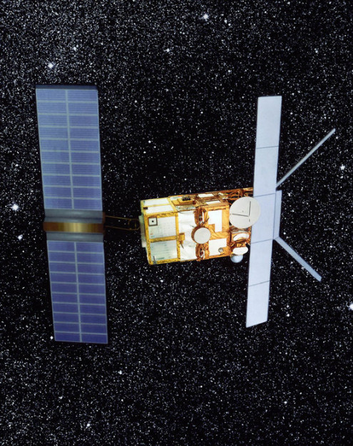
ERS-1. The first European radar satellite, and the first of ESA’ earth observing satellites.
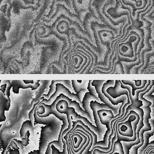
“The upper part of the image shows a raw interferogram for a pair of images from ESA’s ERS-satellites. The area is from northern Finland and has moderate terrain relief. The lower part shows the filtered version of the interferogram, from which it is easy to ‘unwrap’ the phase history and generate a digital terrain height model”.
The completely new technique of satellite radar interferometry was introduced already with ERS-1, by combining data from separate orbits. Two radars in nearly the same orbit introduced radar interferometry, a very useful application, and this introduced an increased use of radar satellites for more land-based applications. Developing this technique was a great step forward, and the technique is today used in commercial satellite systems as TerraSar-X and TanDEM-X.
At that time ESA worked intensively with the so-called Polar Platform, a large multipurpose satellite in polar orbit with nearly all types of sensors placed at the same satellite. This programme became too ambitious, and after a while the project was divided in two projects; Envisat and Metop. Envisat was mainly a research satellite, while Metop was an operational meteorological satellite, and was to become the first European low Earth orbit meteorological satellite.
Envisat, launched in 2002, supported a broad part of the scientific community with the combination of instruments. The satellite introduced, together with well-proven instruments from ERS, the optical Meris instrument, originally developed for ocean colour observations, but also very useful for land applications and has been a source for many of the beautiful pictures of the Earth.
-Today we are familiar with ESA’s Living Planet Programme. At what time was the Living Planet introduced and why?
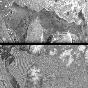
“The upper part shows a regular SAR-image from ESA’s ERS-satellites for an area in the Yamal peninsula in northern Russia. The image shows an area with low terrain relief on land, and also a frozen ocean area. The lower image is an interferogram of the same are. On land the terrain relief can be easily seen. The ocean area in the SAR-image shows little information on the frozen ocean area, while in the interferogram ice floes can be easily distinguished, with relatively clear borders. Because these ice floes have been moving a few centimeters vertically with respect to each other, the resulting phase differences clearly show the outlines of the floes”.
After Envisat was developed and ready for launch, Europe had no plans for the next step in the earth observation programme. However, in the mid-nineties ESA, EU and EUMETSAT chiselled out the Living Planet Programme, a roadmap for the next decades both for research and for operational earth observation. In this strategy the programme was divided in two parts, Earth Explorer and Earth Watch.
Earth Explorer is a series of research satellites, aimed at giving the science community the best data for further research. Earth Watch is a satellite series designed to monitor the Earth on a continuous basis. It contains the Eumetsat meteorological satellites, and the satellites for the EU administrated Global Monitoring for Environmental and Security (GMES) programme, now called Copernicus.
The original name for the GMES programme was “Global Monitoring for Environmental Security”. Later the name was changed to ” Global Monitoring for Environment and Security”, thus, the Earth Watch programme includes all types of civil security, not only environmental security.
The Earth Explorer programme is a rolling forward programme, implemented as contiguous five-year periods. Cryosat, GOCE, SMOS and Swarm are launched and GOCE has also already fulfilled its mission, while Swarm is in the commissioning phase. Aeolus, Earthcare and Biomass will follow, the last one in 2020, but the programme will not end there. New mission candidates are continuously analysed based on proposals from the scientific community.
The Earth Explorer missions are divided into Core missions or Opportunity missions. A Core Mission is a large mission mainly developed, built and operated by ESA, while the Opportunity Missions can be built and operated by other organisations. In addition, a third category, small missions, has been introduced as well.
ESA has a key role in Copernicus; to develop and build the satellites that are necessary to fulfil the programme’s need for data, the Sentinel satellites. Sentinels have to a large degree the same instruments as on Envisat, but placed at different platforms, except for Sentinel 2, which is an optical satellite, a mission the French Spot satellites previously have covered. In addition to delivering operational data, the Earth Watch satellites will be very valuable research satellites.
The logic is very clear; all new satellites shall continue and extend the data provision ERS and Envisat started.
In addition to the Sentinel satellites, Copernicus will also use data from so-called Contributing Missions; research, operational, governmental or commercial satellites from countries worldwide. The EUMETSAT meteorological satellites are also part of the system and the future Metosat Third Generation (MTG) and MetOp-SG (second generation) will be platforms for Sentinels 4 and 5.
If Copernicus evolves as planned, the programme will get a status within earth observation like EUMETSAT has for the meteorological observation. The plan is to continue the current programme towards 2035. After that, the technological development has taken new steps and, undoubtedly, new generations of satellites will continue the services that have now started.
Copernicus is running well today; in spite of some economical challenges connected to financing. The first Sentinel satellite is already successfully launched and the next three will follow later in 2014 and 2015.
-Satellite technology has had a continuous evolution since the first sensors in space five decades ago. What will we see in the future?
-I do not believe we will see large quantum jumps in the technological development of sensors, but rather a continuous improvement of existing technology. It is complicated and expensive technology, and it takes time to develop, but an important trend is the introduction of small satellites and groups of satellites operating and being used together.
Spectrometry that can characterise atmospheric constituents and types of surfaces is a technology that will be further developed. IASI at the Metop satellites is such an instrument. There is a gap between microwave and optical frequencies where new sensors are being introduced.
Models are the foundations for much of the meteorological and climate forecasting. Improving the models means improved forecasts. To deliver better models, higher computer capacity is not the only solution; the instruments in space must also deliver more data, and data with higher resolution.
For detection of ocean currents, today’s satellites with sufficient coverage have a resolution in the range of kilometres. However, much of the ocean currents are on a small scale, and higher resolution is one of the requirements from the scientists, not only for ocean monitoring. Thus, this is a future research field. Norwegian fjords are an example where higher resolution is a needed, where Sentinel 3 will deliver much better data than existing satellites.
A new trend is constellations, using several satellites to take measurements nearly simultaneously like interferometry. Identical sensors or satellites can pass the same point of the world with short intervals. Some separated by hours, others possibly by intervals of seconds. The American A-train constellation is such a constellation. They are not identical satellites, but they pass the same place on Earth with short intervals and take supplementary measurements.
The number of small national or privately owned satellites will increase, because the threshold to build and launch small satellites has decreased. Delivering earth observation data is not only reserved governmental organisations. Now we see a lot of commercial operators, mainly within monitoring and mapping, and if the economical basis is there, all types of Earth observation can be commercial.
The Earth Explorer satellites are mainly dedicated to a specific research area, which also means that they address specific research communities. This is very complementary to the data provided from the Sentinel satellites, which can be used to address a broad range of research questions.
-What about the orbits. Have they found their form?
Near polar orbits are the main orbits for nearly all types of earth observation satellites, except for the geostationary meteorological satellites. The advantages are many. They can cover the whole earth 24/7 if the swath is sufficient, they can pass the same point of the earth every day, if they are sun-synchronous and can daily detect all changes in the weather or environment and. By using long time series, they can detect changes in the climate. It is therefore very important to use comparable instruments in different generations of earth observing satellites; they will give good pictures of the climatic trends.
For continual view of a continent, geostationary satellites are a good tool, since staying over the same point of Earth they daily follow the meteorological and environmental evolution. Several nations have this kind of satellites, and Europe has the Meteosat series of satellites.
-I am sure these two types of orbits will be the main orbits, also in the future.
-However, there are exceptions where satellites have other orbits. The Jason ocean altimetry mission has a circular orbit at an altitude at 1336 km and inclination at 66 degree. Jason has no sun synchronous orbit, because the altimeter must correct the received data for the tide effect. An inclination between 0 and 30 degree for example, will give detailed information of regions around Equator.
Another type of orbit is the Molnya orbit, a highly eccentric orbit with a low point at few hundred kilometres and a high point of about 40,000 kilometres, mainly developed for communication, but is also useful for meteorology. Such orbits provide very good coverage of high latitudes and are proposed for the Canadian Polar Communication and Weather (PCW) satellite system.
Satellites in the Lagrangian point L1 are also proposed. A satellite there could give a very good survey over the Earth, but at very long distance.
Some facts
Seasat
The American satellite Seasat, launched in June 27, 1978, is regarded as the first earth observation satellite with an imaging radar. Seasat was the first satellite designed for remote sensing of the Earth’s oceans with synthetic aperture radar (SAR). Although only approximately 42 hours of real time data was received, the mission demonstrated the feasibility of using microwave sensors to monitor ocean conditions, and laid the groundwork for future SAR missions.
Infrared Atmospheric Sounding Interferometer
IASI, the Infrared Atmospheric Sounding Interferometer has been designed for operational meteorological soundings. It is also designed for atmospheric chemistry aiming at estimating and monitoring trace gases like ozone, methane or carbon monoxide on a global scale.