

Norway’s Intention to Build and Operate Communication Systems for the Artic Areas
Warmer climate and a desire to utilise natural resources, has led to an increased activity in the Arctic and the near Arctic areas, and similarly, the need for adequate communication has also increased. Today the communication systems are not the best. Traditional radio communication has low rate and geomagnetic activity often interferes and destroys communication systems. Communication via geostationary satellites are not possible at the highest latitudes because very low elevation for the satellites. Existing communication satellites in low earth orbits pass over the area but has for the most part low data rate. In short, communication between people and to vital installations in these areas far north is relatively problematic.
The need for high speed broadband communication service for people and installations in these areas has increased, not only on the same level as the increasing activities, but also on the same level as for people’s demand for high speed broadband, 24/7. Easy and stable communication is important for all activities in the far north regarding marine traffic, fishery and research. To be able to offer the service, the Norwegian company, Space Norway, has been working to establish satellite-based capacity for broadband communication in the north areas since 2015.
The project is based on the use of two satellites in high elliptical orbits, something that will give high speed communication 24/7, covering areas over the 65 degree of latitude, nearly five degree south of the Arctic Circle.
The communication is based on two satellites in elliptical orbits, with an altitude over Arctic at 43 000 kilometres and over the Antarctica at 8000 km, providing communication with the satellite eight hours an orbit and with two satellites in service continuous coverage of the area north of the 65 longitude. By comparison, geostationary orbit satellites have a height of 36 000 km over the Equator.
The plan is to launch the satellites in 2022 and, dependent on choice of orbit raising system, the satellites can have the right orbit height sometime in 2023. The plan is to have a finalised contractor ready by April 2019. Norway does not have any prior competence in building satellites and relies heavily on companies that can be suppliers for the contractors and satellite builders.
The project will be funded by and owned by Space Norway. The communication rental charge will be the outcome for the company. The system will be operated from Norway.
Space Norway
Highly Elliptical Orbits (HEO)
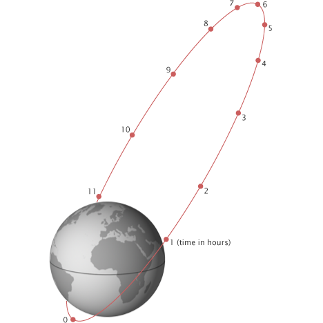
The prinsip of an Molniya Orbit. Short period above the South Pole, long period above the North Pole.
Figure: Wikipedia
Highly Elliptical Orbits (HEO), are satellite orbits with very high eccentricity related tor more circular orbits most of the satellites use. With very high eccentricity polar orbits the satellites will hang over the polar areas for a long time before they return to a much shorter time over the other pole. Two satellites in opposite place in the orbit give continuous contact from all places in the Arctic, or Antarctic, areas.
For any ellipse, there are two focal points, and one of these is the geo-centre of the Earth. Another feature of an elliptical orbit is that there are two other major points. One is where the satellite is furthest from the Earth, known as the apogee. Here the satellite moves the slowest and the gravitational pull from the Earth is the lowest. The other point is called perigee and at this point the satellite moves the fastest.
If the satellite orbit is very elliptical, the satellite will spend most of the time near apogee where it moves very slowly. This means that the satellite can be in view over its operational area for most of the time and fall out of view when the satellite comes closer to the earth and passes over the blind zone of the Earth. When placing two satellites in the same orbit, continuous contact can be established. The orbital plane will for the most have a low inclination related to the north-south axis, but not necessarily. The orbit can also have an inclination around the equatorial plane.
The special orbits are often called Molniya orbits, named after the former Soviet communication satellites that were the first to use this type of orbit to cover the northeast parts of present-day Russia. The orbit has also been called the tundra orbit.
Featured image: Greenland seen from an airplane. Photo: NordicSpace