
Cooperation between the Finnish ICEYE and the Norwegian KSAT it will be possible to deliver complete SAR images to the customer within fifteen minutes after the satellite has taken the pictures.
Through two decades of acquisition of radar pictures from space, the customers have had the possibility to detect details on earth every time, independent of clouds and darkness. However, the major drawback to this is that the processing time has been too long in order to provide updated information. However, over time such satellites have improved the delivering time, and now the constellation ICERYE and KSAT has broken the fifteen minutes’ limit. Through their cooperation the customers can receive updated information only fifteen minutes after overflying of the satellite.
KSAT, an abbreviation for Kongsberg Satellite Services, through its own global ground network and partner stations can now receive data from the satellites from almost all parts of an orbit. It secures that the company has the raw-data only minutes after the satellite has taken the picture. The next step is to process the raw data to useful information for the customers.
Through its own processing capacity, KSAT now delivers near end products to customers very quickly. Radar data with critical timelines e.g. oil slick monitoring, vessel detection and ice monitoring is now delivered nearly consecutively to the customers.
A polar orbiting satellite needs about ninety minutes to orbit the earth, and several orbits to monitor the whole earth. One satellite therefore does not deliver updated information everywhere on earth, more satellites are needed to meet the demands. The Finnish company ICEYE, through ground-breaking new techniques, now builds and launches very small low-cost satellites to a constellation that can overfly all places on Earth several times every day. The complete constellation will be capable of imaging Earth every three hours, day and night, regardless of cloud covers.
This will provide a much better basis for the decision makers, governmental or commercial.
Better Decision Making for Everyone
ICEYE provides commercial access to timely and reliable Earth observation data. The ICEYE SAR Satellite Constellation is capable of imaging any location on Earth every three hours, day and night, regardless of cloud covers.
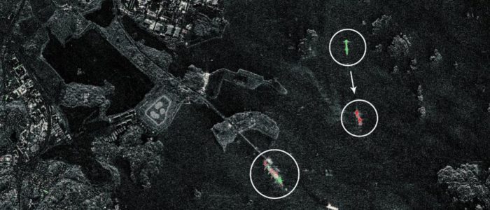
Featured Image:
A radar image from Iceye showing the movements of wessels in the port of Gotheburg, Sweden.