
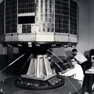
Sixty years ago, meteorologist for the first time could see the Earth’s weather systems from observatories high above the clouds. The world’s first meteorologically satellite, the American TIROS, from a height of more than six hundred kilometres above the Earth could follow the development of the cloud systems and their movements above Earth.
TIROS -1, which stands for Television Infrared Observatory Satellite number one, was operative for 78 days and sent back more than 19,000 usable pictures and opened the door space monitoring of the weather system on Earth. TIROS-1 over the nex years was followed by several new satellites of the same type, but with increasingly advanced technology.
The first pictures from space enthused most of the meteorological community and the development of new types of sensors and instruments increased. Today, most of the data meteorologists need come from instruments placed in space – space born instruments in different types of orbits, and in different heights above the Earth’s surface.
The USA together with the Soviet Union, was for many years the leading actors within the field, but in 1983 twenty European countries established the European Organisation for the Exploitation of Meteorological Satellites, EUMETSAT, and Europe has ever since been one of the leading participants within using satellites to secure reliable forecasts.
The European system consists of both satellites in geostationary orbits, the Metop system, and polar orbiting satellites, the Meteosat system. The first system has the same longitude all the time, while the polar orbiting satellites circle the sun in synchronous orbits and passes the same place of the Earth at the same time, every day.
These are the operative systems. In addition, different research satellites in ESA’s Earth Explorer and Earth Watch programmes contribute to meteorological information, a better understanding of the weather systems and to the development of the new generations of meteorological sensors. One example is ESA’s wind mission Aeolus. This satellite provides the meteorologists with proper wind measurements from space – and is a great step forward.
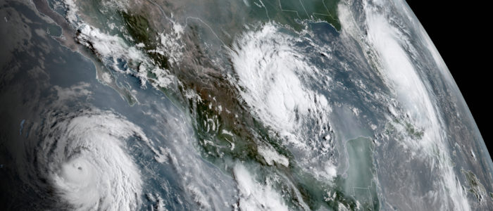
Featured Picture.
Hurricanes in the Caribbian area. Credit: NOAA.